Minimise risks to your employees, assets and the general
public by estimating
the population of any UK location at any time of day or
night.
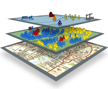 The National Population Database
is a unique Geographical Information System (GIS) dataset
that enables the estimation of residents, workers and other
population types in any location, down to individual building
level, in Great Britain.
The National Population Database
is a unique Geographical Information System (GIS) dataset
that enables the estimation of residents, workers and other
population types in any location, down to individual building
level, in Great Britain.
The NPD uses the latest and most accurate data available, and
provides unmatched levels of granularity.
Watch our video introduction of the tool below. Can't see
the video?
View it here
An
invaluable risk management tool for businesses with UK-wide
operations
The NPD can be used to assess the risk to people from major
hazards:
- to minimise the risk associated with major building works of
infrastructure upgrades by construction or utilities companies
- to enable telecoms providers to optimally position mobile
communications masts, thereby ensuring maximum coverage in any
given location
- to provide traffic management modelling capabilities for
transport companies
- to give businesses confidence in their emergency resilience or
disaster recovery planning
Population data trusted by government
The NPD's dataset is used by the UK government's 'Resilience
Direct' platform. This secure online network for sharing real time
information enables emergency services to deliver an efficient and
co-ordinated response in situations that impact civil
protection.
How the
Department for Transport used HSE's National Population Database to
inform transport investment in Great Britain
How the National Population Database Assisted in the pandemic
response
News article:
Celebrating Geographical Information Systems (GIS) and the role
they play within HSE
More information and access to the tool
The NPD
portal lets you experiment with the different layers using data
for an area in the south-east of Manchester. Based on the ArcGIS
website, you don't need any installed GIS software.
Visit the portal for more information on the tool. To make an
enquiry contact our NPD Team
directly.