How the National Population Database Assisted in the Pandemic Response
The Challenge
Back in 2020, at the beginning of the COVID-19 pandemic, we saw
an opportunity to assist the national response effort. By making
the National Population Database (NPD) available to organisations
co-ordinating social distancing measures, we could play our part in
what was to be a long-term fight against the virus.
The Solution
The NPD is a unique Geographical Information System (GIS)
dataset that enables the numbers of residents, workers and other
population types to be estimated in any location, down to
individual building level, in Great Britain. Developed by the
Health and Safety Executive (HSE), the dataset pulls together HSE's
own data with information from Ordnance Survey and Royal Mail,
presenting it on a map using a purpose-built portal.
The NPD's dataset is so trusted and reliable that it is used by
the UK Government's 'Resilience Direct' platform. This secure,
online network for sharing real time information enables emergency
services to deliver an efficient and co-ordinated response in
situations that impact civil protection.
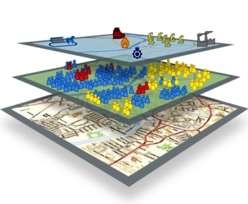
By presenting valuable population data in layers, the NPD can
present population hotspots on a map for different times of
the day and night. Population types are shown by building (schools,
hospitals, prisons and others) or at a 100 metre grid level if a
wider overview of a location is required. Even greater detail means
that users can fine-tune data to their particular application; for
example, the Schools layer includes separate figures for primary,
secondary and tertiary students as well as the total figure across
all ages.
The NPD's many layers and multiple population types allow you to
create specific population scenarios. For instance, consider the
fictional scenario of a toxic plume being released near the
Meadowhall shopping centre in Sheffield on a Wednesday between 1
and 2pm. For a realistic summary of that time and place, you would
include the school, childcare and care home layers and pick daytime
populations from the residential and workplace layers. Having
entered the plume dimensions, the NPD can be used to help estimate
the risk, by assessing the numbers of people affected in each
category as well as the number and type of buildings and other
infrastructure under the plume.
The Outcome
A number of organisations used the NPD as part of their pandemic
planning and response efforts between April 2020 and Sept 2021:
- Cabinet Office
- Joint Biosecurity Centre/Dept Health and Social Care (Test and
Trace)
- Home Office
- Scottish Govt / Public Health Scotland
- Welsh Government
- Ministry of Defence
- Hampshire County Council
- Ordnance Survey


The NPD is being used to provide contextual information for
industry and workforce breakdowns. It will continue to provide
useful insight into regional variations in industry and employment
beyond the pandemic. [JBC/DHSC];
the data was really useful throughout the pandemic, and was
used for analysis work around co-ordinating covid response.
[MoD];
See for yourself!
The NPD
portal lets you experiment on a demonstration dataset. How
would you use it?
Watch our video introduction of the tool below. Can't
see the video? View it here
Contact us for more information: npd@hse.gov.uk
Back to the top